Mission Planning
Prior to a dive, the NavPoint software is used to create a "Mission" file that is downloaded via the USB interface into Artemis's internal memory.
The Mission file defines a series of markers that may be graphically designated either as a "Waypoint" or "Target", with customisable display colour and name. Marker coordinates can either be entered manually or created in third-party programs (such as Google Earth™) and improted using CSV or KML formats.

GPS Position
To obtain the divers position, Artemis connects to a floating GPS receiver that the diver tows behind them. When a precise positional fix is required, the diver can pull in the umbilical cable to ensure the float is directly above them.
 Navigation Display
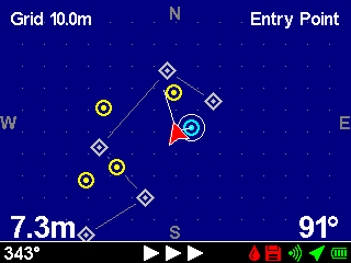
During the dive, the diver can select a marker from the Mission file as their navigation destination, and Artemis will use the information from its internal heading, depth and additide sensors along with the position information from the GPS float to produce a continuously updated navigation solution for the diver.
In the 'Navigation App', a geographical chart display shows the divers heading, divers position and destination marker position, while 'Heading To Swim' and 'Distance To Destination' numerical values are shown at the bottom of the display.
Swim Guide
Regardless of the main display being shown, the status bar is always visible along the bottom of the screen and this provides a simple graphical heading indicator to guide the diver to their destination. If the diver is more than 30°, 60° or 90° off the desired heading, 1, 2 or 3 arrows indicate they should turn left of right, while below 30° a circular 'bubble' moves across the status bar to allow fine tuning of the course.