

PinPoint is a Windows software application that allows users to track up to 14 underwater assets, each fitted with a SeaTrac acoustic beacon, from a single USBL beacon.
PinPoint has a variety of features to help users perform positioning, navigation and survey tasks, including the logging and playback of operational data, interfaces to satellite positioning systems, geographic markers, waypoint and destination navigation information and real-time data output to other NEMA compatible systems.
Data logged during operations can be reviewed while a job is still in progress, and PinPoint can export geographic data in a variety of third party formats, including KML and CSV.
PinPoint is compatible with Windows 10, 8 and 7 and requires a PC with one free Serial port, or USB port and customer supplied USB-to-Serial converter.
 Intuitive Navigation Display
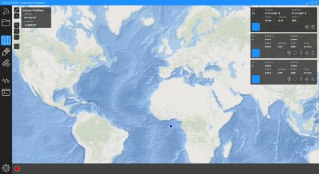
The interactive navigation display shows the user an overview of tracked underwater assets, allowing functions such as zooming, rotating, panning and measurements to be performed.
Additionally, the display can be focussed on any specific asset and rotated to align with the remote heading telemetry transmitted by the beacon, aiding ROV pilots to determine their vehicles position and the location of surrounding marked targets or other beacons.
Using DirectX graphics hardware rendering, the navigation display provides a crisp and responsive representation of sub-sea operational area, supporting both Polar and Cartesian grids, metric and imperial measurement units, and a wide range of geodetic reference systems including WGS84.
 Local Beacon
PinPoint requires a single X150 USBL head to be mounted from the operators vessel or platform. Offsets can be specified for the location of the GPS receiver (or other geodetic reference input) and the position of the beacon relative to the platform.
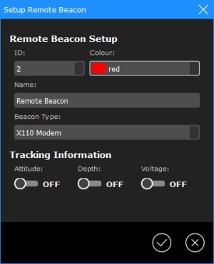
Remote Beacons
Up to 14 remote beacons can be tracked acoustically using the PinPoint software, each having a configurable visual history track overlaid onto the display.
Underwater assets can be easily identified as each beacon can be assigned a name, graphical representation and colour, and additionally their remotely transmitted depth (for enhanced positioning), attitude and heading, can also be overlaid onto the display.
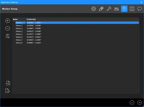 Markers
PinPoint allows the user to add fixed-position markers represented by specifying a latitude, longitude and depth. These markers are visible on the main navigation display and can be used as targets for any of the remote beacons.
Markers can be imported into PinPoint from third party applications in a variety of file formats including KML and CSV.
