Scanline is the user-friendly data acquisition and logging software package for StarFish Seabed Imaging Systems.
Operating from any 32bit or 64bit Microsoft® Windows® 2000/XP/Vista/7/8 based PC or laptop to capture and display real-time StarFish side scan sonar data. Scanline can also acquire data from several other sensors including GPS, compasses and speedometers and all data can be recorded, replayed and exported from the software.
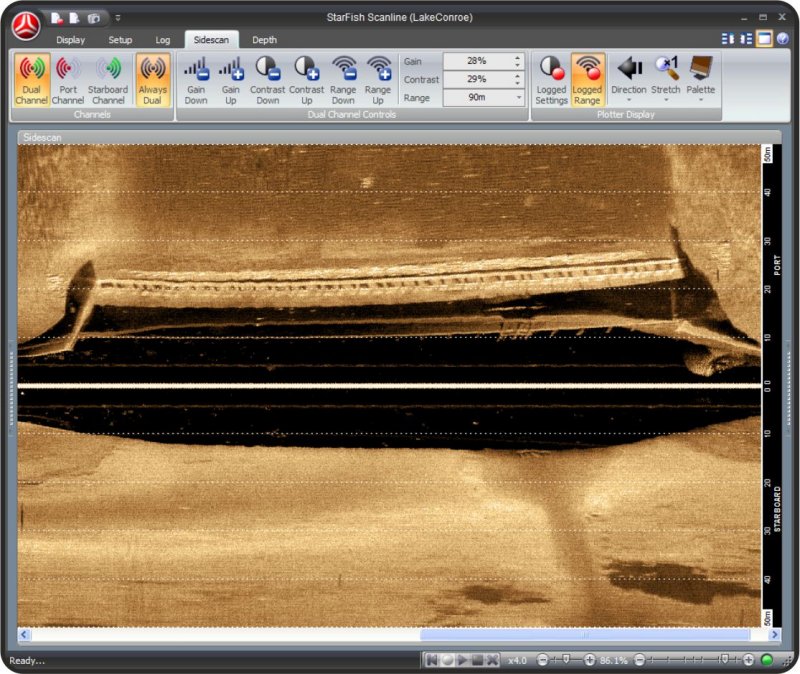
Sonar Display


The sidescan plotter window displays sonar data as a standard 'waterfall' image. The operator can control whether port, starboard, or both sonar channels are active and displaying data.
Side scan data can be magnified or stretched to change the aspect ratio of seafloor targets and help aid in their identification, and the orientation of data plotting on the display can be changed (from top-to-bottom, left-to-right, or vice-versa) to help users interpret real-time sonar data relative to the boat.
Gain, Contrast and Range settings for the sonar can be altered using standard 'dual channel' controls but more experienced users can choose to independently control these settings for each channel if they wish.
Depth Display
A depth plotter will display altitude of the sonar above the seabed. The depth value can come from either processed sonar data or an echosounder.

Display Widgets
Scanline uses Widgets to provide extra control, functionality or show data from hardware sensors. Widgets can be displayed on either side of the main display, and rolled-up when not in use to maximise available space. Default Widgets include Vessel Details (Heading / Velocity / Position), Log Player, Hardware Manager and GPS Satellites.
 Hardware Management
Scanline's easy-to-use Hardware Manager interface means you'll be up and running in no time. Users can quickly add, remove and configure all hardware devices recognised by the software in one location, with built in support for StarFish and third party NMEA-0183 compliant compasses, speedometers, depth-sounders and GPS receivers.

Ribbon Bar Interface
A Tabbed ribbon-styled interface with large icons, simplifies operation and allows all settings and controls to be easily accessed when operating outdoors in bright sunlight, or on touch-screens.

Time Saving Wizards
Scanlines extensive use of “Wizards” makes tasks such as setting up the hardware, software and operating parameters (like “velocity of sound”), simple, quick and easy.
Interactive Displays
All the display plotters in Scanline provide interactive functions for use by the user. Dragging the Sonar display with the mouse allows historical data to be viewed, with the current viewing area highlighted on the depth plotter.
When the cursor is moved over a sonar target, the associated depth and position information if hardware such as GPS is attached) will be shown in the status bar.

Help & Support
We know that using a sonar system can be daunting. So, whether you’re using StarFish for the first time, or trying get the best results from your system we’ve written a comprehensive integrated help system, covering every aspect of using your sonar, through to advice with interpreting the images it produces.
The built-in web browser window within Scanline allows users with an active internet connection on their PC or laptop to view online content from the StarFish website and read the very latest StarFish news headlines, and download the latest StarFish Scanline software updates for free from the support section of the StarFish website.
Other Features
- For users requiring advanced post-processing of logged data, Scanline's Data Export Wizard will convert existing StarFish log files into industry standard XTF (eXtended Triton Format) or CSV (Comma Separated Value) text file formats, suitable for use in third party analysis software.
- Screen capture or 'snapshot' function allow the current display window contents to be saved to an image file (BMP, PNG, TIFF or JPG).
- Sensor readings displayed in user selectable metric and imperial measurement systems. Positional information in latitude/longitude or UTM coordinate systems.
- Compatible with 32-bit and 64-bit versions of Microsoft Windows XP, Vista, 7 and 8 operating systems.